


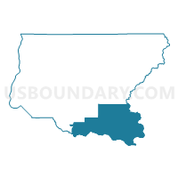
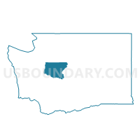
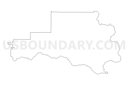
Chinook Voting District, King County, Washington
About
Outline

Summary
| Unique Area Identifier | 685506 |
| Name | Chinook Voting District |
| County | King County |
| State | Washington |
| Area (square miles) | 322.17 |
| Land Area (square miles) | 320.89 |
| Water Area (square miles) | 1.29 |
| % of Land Area | 99.60 |
| % of Water Area | 0.40 |
| Latitude of the Internal Point | 47.22052710 |
| Longtitude of the Internal Point | -121.59358330 |
Maps

Graphs
Select a template below for downloading or customizing gragh for Chinook Voting District, King County, Washington


Neighbors
Neighoring Voting District (by Name) Neighboring Voting District on the Map
- Voting District 31-671, Pierce County, WA
- Voting District 31-672, Pierce County, WA
- Birch Voting District, King County, WA
- Cedar River Voting District, King County, WA
- Cliffdell Voting District, Yakima County, WA
- Easton Voting District, Kittitas County, WA
- ENM 31-0410 Voting District, King County, WA
- ENM 31-0411 Voting District, King County, WA
- ENM 31-3247 Voting District, King County, WA
- Falcon Voting District, King County, WA
- Hyak Voting District, Kittitas County, WA
- Sierra Voting District, King County, WA
- Twin Falls Voting District, King County, WA
- Veazie Voting District, King County, WA
Top 10 Neighboring County Subdivision (by Population) Neighboring County Subdivision on the Map
- Enumclaw Plateau CCD, King County, WA (63,367)
- Snoqualmie Valley CCD, King County, WA (48,362)
- Buckley CCD, Pierce County, WA (21,379)
- Northwest Yakima CCD, Yakima County, WA (8,252)
- Cle Elum CCD, Kittitas County, WA (6,339)
- Manastash Ridge CCD, Kittitas County, WA (5,238)
- Mount Rainier CCD, Pierce County, WA (3,406)
Top 10 Neighboring Place (by Population) Neighboring Place on the Map
Top 10 Neighboring Unified School District (by Population) Neighboring Unified School District on the Map
- Tahoma School District, WA (37,376)
- Snoqualmie Valley School District, WA (35,054)
- Enumclaw School District, WA (25,179)
- White River School District, WA (22,116)
- Naches Valley School District, WA (8,078)
- Cle Elum-Roslyn School District, WA (7,379)
- Thorp School District, WA (1,402)
- Easton School District, WA (1,134)
Top 10 Neighboring State Legislative District Lower Chamber (by Population) Neighboring State Legislative District Lower Chamber on the Map
- State House District 5, WA (161,403)
- State House District 13, WA (143,750)
- State House District 31, WA (137,685)
- State House District 14, WA (130,478)
Top 10 Neighboring State Legislative District Upper Chamber (by Population) Neighboring State Legislative District Upper Chamber on the Map
- State Senate District 5, WA (161,403)
- State Senate District 13, WA (143,750)
- State Senate District 31, WA (137,685)
- State Senate District 14, WA (130,478)
Top 10 Neighboring 111th Congressional District (by Population) Neighboring 111th Congressional District on the Map
Top 10 Neighboring Census Tract (by Population) Neighboring Census Tract on the Map
- Census Tract 327.02, King County, WA (6,545)
- Census Tract 9751, Kittitas County, WA (6,339)
- Census Tract 314, King County, WA (5,780)
- Census Tract 9752, Kittitas County, WA (5,238)
- Census Tract 702.07, Pierce County, WA (4,948)
- Census Tract 30.01, Yakima County, WA (4,584)
- Census Tract 315.02, King County, WA (3,876)
- Census Tract 701, Pierce County, WA (3,406)
Top 10 Neighboring 5-Digit ZIP Code Tabulation Area (by Population) Neighboring 5-Digit ZIP Code Tabulation Area on the Map
- 98022, WA (20,987)
- 98321, WA (15,152)
- 98045, WA (13,888)
- 98937, WA (4,112)
- 98323, WA (702)
- 98925, WA (689)